Ḩātim night lights from space
Night Light of Ḩātim (Irbid) from space (Jordan) Src. Average luminocity for 10x10km area is 49.3339% and for 50x50km: 34.1518%.
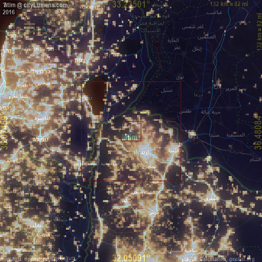
Analysis of Ḩātim night lights 2016
Square area 10x10 km:
100  1.05%
1.05%
90-99 3.32%
80-89 9.09%
70-79 10.49%
60-69 8.57%
50-59 9.97%
40-49 17.66%
30-39 15.56%
20-29 19.58%
10-19 4.72%
0-9 0%
1.05%90-99
3.32%80-89
9.09%70-79
10.49%60-69
8.57%50-59
9.97%40-49
17.66%30-39
15.56%20-29
19.58%10-19
4.72%0-9
0%Square area 50x50 km:
100 2.29%
90-99 3.02%
80-89 7.92%
70-79 6.65%
60-69 4.33%
50-59 5.48%
40-49 7.19%
30-39 6.56%
20-29 11.48%
10-19 18.7%
0-9 26.38%
2.29%90-99
3.02%80-89
7.92%70-79
6.65%60-69
4.33%50-59
5.48%40-49
7.19%30-39
6.56%20-29
11.48%10-19
18.7%0-9
26.38%Clear (daylight) street map image can be seen on geolist.org.
Map coordinates:
33° 14' 6" North, 35° 4' 28.5" East
32° 38' 41.7" North, 35° 46' 39.8" East
32° 3' 3.3" North, 36° 28' 51" East
Some cities around Ḩātim sort by population:
• Şammā
11.6 km =7.2 mi,  225°
225°
• Kafr Asad
8 km =5 mi, 229°
• Kafr Sawm
5 km =3.1 mi,  25°
25°
• Ḩakamā
11.4 km =7.1 mi,  120°
120°
• Malkā
4.4 km =2.7 mi,  322°
322°
• Saḩam al Kaffārāt
6 km =3.7 mi,  357°
357°
• Kharjā
10.4 km =6.5 mi,  80°
80°
• Qumaym
9.1 km =5.7 mi,  206°
206°
249184 (p: 5,542)
Sources (retrieved 2019-11-25):
» Earth at Night: Flat Maps 2012, 2016