Tibnah night lights from space
Night Light of Tibnah (Irbid) from space (Jordan) Src. Average luminocity for 10x10km area is 45.6703% and for 50x50km: 42.6124%.
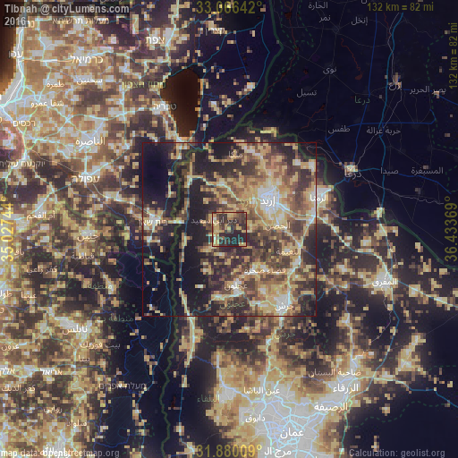
Analysis of Tibnah night lights 2016
Square area 10x10 km:
100  0.92%
0.92%
90-99 1.65%
80-89 8.42%
70-79 14.47%
60-69 6.41%
50-59 4.4%
40-49 11.9%
30-39 14.1%
20-29 34.25%
10-19 3.48%
0-9 0%
0.92%90-99
1.65%80-89
8.42%70-79
14.47%60-69
6.41%50-59
4.4%40-49
11.9%30-39
14.1%20-29
34.25%10-19
3.48%0-9
0%Square area 50x50 km:
100 2.81%
90-99 4.11%
80-89 9.74%
70-79 8.19%
60-69 5.91%
50-59 6.85%
40-49 10.56%
30-39 9.14%
20-29 13.11%
10-19 17.37%
0-9 12.21%
2.81%90-99
4.11%80-89
9.74%70-79
8.19%60-69
5.91%50-59
6.85%40-49
10.56%30-39
9.14%20-29
13.11%10-19
17.37%0-9
12.21%Clear (daylight) street map image can be seen on geolist.org.
Map coordinates:
33° 3' 59.1" North, 35° 1' 38.8" East
32° 28' 30.8" North, 35° 43' 50" East
31° 52' 48.3" North, 36° 26' 1.3" East
Some cities around Tibnah sort by population:
• Judita
7.8 km =4.8 mi,  195°
195°
• Aţ Ţayyibah
7.6 km =4.7 mi,  350°
350°
• Şammā
11.3 km =7 mi,  340°
340°
• Bayt Yāfā
7.4 km =4.6 mi,  44°
44°
• Kafr Abīl
9 km =5.6 mi,  224°
224°
• Dayr Yūsuf
6.3 km =3.9 mi,  77°
77°
• Ḩalāwah
12 km =7.5 mi,  212°
212°
• Qumaym
10.7 km =6.6 mi,  1°
1°
246522 (p: 5,229)
Sources (retrieved 2019-11-25):
» Earth at Night: Flat Maps 2012, 2016