Qumaym night lights from space
Night Light of Qumaym (Irbid) from space (Jordan) Src. Average luminocity for 10x10km area is 59.9091% and for 50x50km: 38.7682%.
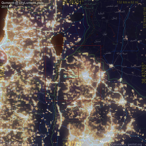
Analysis of Qumaym night lights 2016
Square area 10x10 km:
100  0.7%
0.7%
90-99 2.62%
80-89 16.26%
70-79 16.78%
60-69 13.99%
50-59 18.36%
40-49 16.08%
30-39 5.94%
20-29 9.27%
10-19 0%
0-9 0%
0.7%90-99
2.62%80-89
16.26%70-79
16.78%60-69
13.99%50-59
18.36%40-49
16.08%30-39
5.94%20-29
9.27%10-19
0%0-9
0%Square area 50x50 km:
100 2.46%
90-99 3.48%
80-89 8.88%
70-79 7.34%
60-69 5.27%
50-59 5.95%
40-49 9.56%
30-39 7.91%
20-29 13.14%
10-19 18.08%
0-9 17.93%
2.46%90-99
3.48%80-89
8.88%70-79
7.34%60-69
5.27%50-59
5.95%40-49
9.56%30-39
7.91%20-29
13.14%10-19
18.08%0-9
17.93%Clear (daylight) street map image can be seen on geolist.org.
Map coordinates:
33° 9' 44.3" North, 35° 1' 53" East
32° 34' 18.3" North, 35° 44' 4.3" East
31° 58' 38.1" North, 36° 26' 15.5" East
Some cities around Qumaym sort by population:
• Irbid
11 km =6.8 mi,  99°
99°
• Aţ Ţayyibah
3.6 km =2.2 mi,  206°
206°
• Şammā
4.2 km =2.6 mi,  268°
268°
• Kafr Asad
3.6 km =2.2 mi,  324°
324°
• Bayt Yāfā
7.3 km =4.5 mi,  138°
138°
• Dayr Yūsuf
11.1 km =6.9 mi,  148°
148°
• Ḩātim
9.1 km =5.7 mi,  26°
26°
• Tibnah
10.7 km =6.6 mi,  181°
181°
247496 (p: 5,111)
Sources (retrieved 2019-11-25):
» Earth at Night: Flat Maps 2012, 2016