Runaway Bay night lights from space
Night Light of Runaway Bay (St Ann) from space (Jamaica) Src. Average luminocity for 10x10km area is 15.2417% and for 50x50km: 3.6194%.
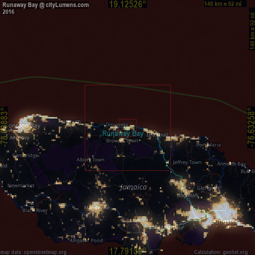
Analysis of Runaway Bay night lights 2016
Square area 10x10 km:
 0%
0%90-99
0%80-89
5.79%70-79
1.86%60-69
2.89%50-59
1.86%40-49
1.65%30-39
1.03%20-29
1.86%10-19
4.55%0-9
78.51%Square area 50x50 km:
0.02%90-99
0.09%80-89
0.89%70-79
0.41%60-69
0.63%50-59
0.48%40-49
0.85%30-39
0.65%20-29
0.58%10-19
1.19%0-9
94.2%Clear (daylight) street map image can be seen on geolist.org.
Map coordinates:
19° 7' 30.9" North, 78° 2' 19.8" West
18° 27' 34.6" North, 77° 20' 8.5" West
17° 47' 29" North, 76° 37' 57.3" West
Some cities around Runaway Bay sort by population:
• Linstead
48.1 km =29.9 mi,  138°
138°
• Saint Ann’s Bay
14.5 km =9 mi,  100°
100°
• Ewarton
40.5 km =25.2 mi, 139°
• Ocho Rios
25.2 km =15.7 mi, 103°
• Port Maria
48.2 km =30 mi, 102°
• Falmouth
34 km =21.1 mi,  276°
276°
• Porus
47.9 km =29.8 mi,  189°
189°
• Point Hill
47.6 km =29.6 mi,  149°
149°
3488726 (p: 6,517)
Sources (retrieved 2019-11-25):
» Earth at Night: Flat Maps 2012, 2016