Port Maria night lights from space
Night Light of Port Maria (St. Mary) from space (Jamaica) Src. Average luminocity for 10x10km area is 4.6508% and for 50x50km: 3.9427%.
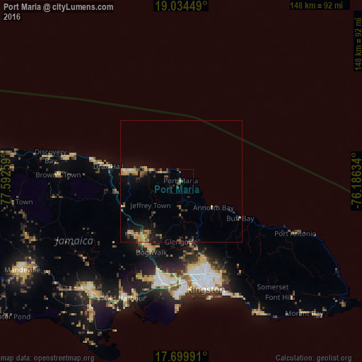
Analysis of Port Maria night lights 2016
Square area 10x10 km:
 0%
0%90-99
0%80-89
0.41%70-79
0.41%60-69
0%50-59
0.41%40-49
3.1%30-39
2.27%20-29
1.65%10-19
1.45%0-9
90.29%Square area 50x50 km:
0.02%90-99
0.06%80-89
0.95%70-79
0.75%60-69
0.48%50-59
0.57%40-49
1.07%30-39
0.7%20-29
0.66%10-19
2.89%0-9
91.85%Clear (daylight) street map image can be seen on geolist.org.
Map coordinates:
19° 2' 4.2" North, 77° 35' 33.3" West
18° 22' 6.6" North, 76° 53' 22.1" West
17° 41' 59.7" North, 76° 11' 10.8" West
Some cities around Port Maria sort by population:
• Linstead
29.8 km =18.5 mi,  210°
210°
• Saint Ann’s Bay
33.7 km =20.9 mi,  282°
282°
• Bog Walk
32.1 km =19.9 mi,  202°
202°
• Constant Spring
36.7 km =22.8 mi,  164°
164°
• Ewarton
29.2 km =18.1 mi,  225°
225°
• Ocho Rios
23 km =14.3 mi, 280°
• Stony Hill
34 km =21.1 mi, 161°
• Annotto Bay
17 km =10.6 mi,  129°
129°
3488985 (p: 7,906)
Sources (retrieved 2019-11-25):
» Earth at Night: Flat Maps 2012, 2016