Falmouth night lights from space
Night Light of Falmouth (Trelawny) from space (Jamaica) Src. Average luminocity for 10x10km area is 18.9008% and for 50x50km: 4.9978%.
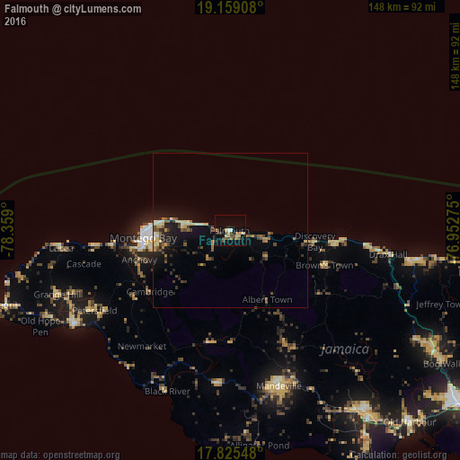
Analysis of Falmouth night lights 2016
Square area 10x10 km:
 1.03%
1.03%90-99
0.83%80-89
5.17%70-79
2.07%60-69
2.27%50-59
2.07%40-49
4.55%30-39
4.75%20-29
0.41%10-19
8.26%0-9
68.6%Square area 50x50 km:
0.15%90-99
0.41%80-89
1.1%70-79
0.44%60-69
0.7%50-59
0.63%40-49
1.01%30-39
0.95%20-29
1.19%10-19
3.57%0-9
89.86%Clear (daylight) street map image can be seen on geolist.org.
Map coordinates:
19° 9' 32.7" North, 78° 21' 32.4" West
18° 29' 36.9" North, 77° 39' 21.1" West
17° 49' 31.7" North, 76° 57' 9.9" West
Some cities around Falmouth sort by population:
• Montego Bay
27.8 km =17.3 mi,  264°
264°
• Mandeville
52.6 km =32.7 mi,  162°
162°
• Saint Ann’s Bay
48.4 km =30.1 mi,  97°
97°
• Santa Cruz
49.2 km =30.6 mi,  185°
185°
• Runaway Bay
34 km =21.1 mi, 96°
• Lucea
54.8 km =34.1 mi,  265°
265°
• Porus
57.1 km =35.5 mi,  153°
153°
• Black River
55.8 km =34.7 mi,  201°
201°
3490520 (p: 7,779)
Sources (retrieved 2019-11-25):
» Earth at Night: Flat Maps 2012, 2016