Porus night lights from space
Night Light of Porus (Manchester) from space (Jamaica) Src. Average luminocity for 10x10km area is 8.9935% and for 50x50km: 9.4846%.
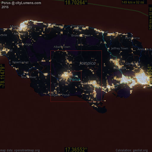
Analysis of Porus night lights 2016
Square area 10x10 km:
 0%
0%90-99
0%80-89
0.87%70-79
0.87%60-69
2.6%50-59
0%40-49
1.73%30-39
1.52%20-29
2.38%10-19
13.85%0-9
76.19%Square area 50x50 km:
0.1%90-99
0.53%80-89
1.75%70-79
1.48%60-69
1.34%50-59
0.93%40-49
1.94%30-39
2.47%20-29
3.81%10-19
8.31%0-9
77.32%Clear (daylight) street map image can be seen on geolist.org.
Map coordinates:
18° 42' 9.5" North, 78° 6' 53.2" West
18° 2' 7.3" North, 77° 24' 42" West
17° 21' 55.9" North, 76° 42' 30.7" West
Some cities around Porus sort by population:
• Mandeville
10.1 km =6.3 mi,  273°
273°
• May Pen
19.3 km =12 mi,  114°
114°
• Old Harbour
33.7 km =20.9 mi, 108°
• Hayes
25.6 km =15.9 mi,  133°
133°
• Santa Cruz
30.4 km =18.9 mi, 273°
• Bull Savanna
25.1 km =15.6 mi,  228°
228°
• Lionel Town
30.9 km =19.2 mi,  144°
144°
• Point Hill
32.7 km =20.3 mi,  79°
79°
3488977 (p: 5,923)
Sources (retrieved 2019-11-25):
» Earth at Night: Flat Maps 2012, 2016