Zola Predosa night lights from space
Night Light of Zola Predosa (Emilia-Romagna) from space (Italy) Src. Average luminocity for 10x10km area is 50.9746% and for 50x50km: 28.3271%.
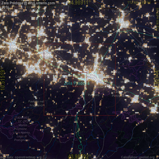
Analysis of Zola Predosa night lights 2016
Square area 10x10 km:
 12.86%
90-99
10.63%80-89
4.44%70-79
4.29%60-69
3.81%50-59
7.78%40-49
6.67%30-39
10.32%20-29
20%10-19
16.83%0-9
2.38%Square area 50x50 km:
5.08%90-99
5.87%80-89
2.51%70-79
2.5%60-69
2.97%50-59
3.31%40-49
3.95%30-39
4.83%20-29
10.76%10-19
21.45%0-9
36.76%Clear (daylight) street map image can be seen on geolist.org.
Map coordinates:
44° 59' 20.8" North, 10° 30' 54.7" East
44° 29' 22.8" North, 11° 13' 5.9" East
43° 59' 9.3" North, 11° 55' 17.2" East
Some cities around Zola Predosa sort by population:
• Bologna
9.6 km =6 mi,  87°
87°
• Casalecchio di Reno
4.8 km =3 mi,  109°
109°
• Progresso
14.5 km =9 mi,  52°
52°
• Anzola dell'Emilia
5.9 km =3.7 mi,  350°
350°
• Calderara di Reno
9.2 km =5.7 mi,  27°
27°
• Bazzano
10.5 km =6.5 mi,  277°
277°
• Sasso Marconi
10.2 km =6.3 mi,  164°
164°
• Rastignano-Carteria di Sesto
12.5 km =7.8 mi,  118°
118°
3163853 (p: 15,965)
Sources (retrieved 2019-11-25):
» Earth at Night: Flat Maps 2012, 2016