Calderara di Reno night lights from space
Night Light of Calderara di Reno (Emilia-Romagna) from space (Italy) Src. Average luminocity for 10x10km area is 54.0379% and for 50x50km: 29.4695%.
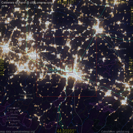
Analysis of Calderara di Reno night lights 2016
Square area 10x10 km:
 12.42%
90-99
12.58%80-89
1.21%70-79
6.21%60-69
7.27%50-59
5.76%40-49
10%30-39
14.09%20-29
22.12%10-19
8.33%0-9
0%Square area 50x50 km:
4.75%90-99
5.83%80-89
2.63%70-79
2.66%60-69
2.95%50-59
2.99%40-49
4.04%30-39
4.9%20-29
10.99%10-19
28.47%0-9
29.8%Clear (daylight) street map image can be seen on geolist.org.
Map coordinates:
45° 3' 42.7" North, 10° 34' 4.8" East
44° 33' 47.1" North, 11° 16' 16" East
44° 3' 35.8" North, 11° 58' 27.3" East
Some cities around Calderara di Reno sort by population:
• Bologna
9.4 km =5.8 mi,  145°
145°
• Casalecchio di Reno
9.7 km =6 mi,  178°
178°
• Castel Maggiore
7.3 km =4.5 mi,  77°
77°
• Zola Predosa
9.2 km =5.7 mi,  207°
207°
• San Giovanni in Persiceto
10.8 km =6.7 mi,  320°
320°
• Progresso
7.4 km =4.6 mi, 84°
• Anzola dell'Emilia
5.7 km =3.5 mi,  245°
245°
• San Giorgio di Piano
12.4 km =7.7 mi,  41°
41°
3181212 (p: 6,287)
Sources (retrieved 2019-11-25):
» Earth at Night: Flat Maps 2012, 2016