Anzola dell'Emilia night lights from space
Night Light of Anzola dell'Emilia (Emilia-Romagna) from space (Italy) Src. Average luminocity for 10x10km area is 53.4921% and for 50x50km: 31.2537%.
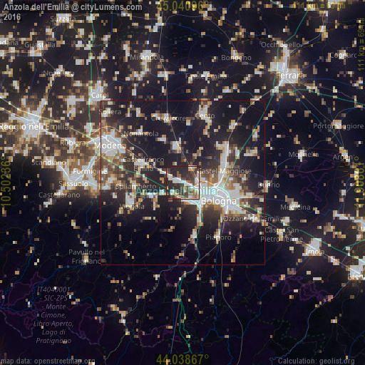
Analysis of Anzola dell'Emilia night lights 2016
Square area 10x10 km:
 9.52%
9.52%90-99
13.02%80-89
3.65%70-79
5.71%60-69
3.81%50-59
10.48%40-49
9.52%30-39
13.17%20-29
26.67%10-19
4.44%0-9
0%Square area 50x50 km:
5.59%90-99
6.47%80-89
2.66%70-79
2.72%60-69
3.2%50-59
3.63%40-49
4.62%30-39
5.26%20-29
11.44%10-19
25.06%0-9
29.36%Clear (daylight) street map image can be seen on geolist.org.
Map coordinates:
45° 2' 27.5" North, 10° 30' 8.5" East
44° 32' 31.1" North, 11° 12' 19.7" East
44° 2' 19.2" North, 11° 54' 31" East
Some cities around Anzola dell'Emilia sort by population:
• Bologna
11.8 km =7.3 mi,  116°
116°
• Casalecchio di Reno
9.2 km =5.7 mi,  143°
143°
• Castel Maggiore
12.9 km =8 mi,  72°
72°
• Zola Predosa
5.9 km =3.7 mi,  170°
170°
• San Giovanni in Persiceto
10.9 km =6.8 mi,  351°
351°
• Progresso
12.9 km =8 mi,  76°
76°
• Calderara di Reno
5.7 km =3.5 mi, 65°
• Bazzano
10.4 km =6.5 mi,  244°
244°
3183002 (p: 8,927)
Sources (retrieved 2019-11-25):
» Earth at Night: Flat Maps 2012, 2016