Viagrande night lights from space
Night Light of Viagrande (Sicily) from space (Italy) Src. Average luminocity for 10x10km area is 83.2262% and for 50x50km: 24.5252%.
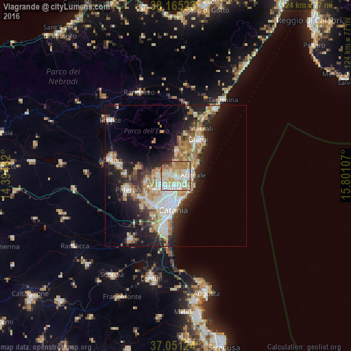
Analysis of Viagrande night lights 2016
Square area 10x10 km:
 20.58%
90-99
24.83%80-89
17.01%70-79
13.78%60-69
17.35%50-59
2.38%40-49
0.68%30-39
1.87%20-29
1.53%10-19
0%0-9
0%Square area 50x50 km:
4.27%90-99
4.63%80-89
3.68%70-79
3.89%60-69
4.06%50-59
2.21%40-49
2.17%30-39
2.89%20-29
6.4%10-19
11.17%0-9
54.6%Clear (daylight) street map image can be seen on geolist.org.
Map coordinates:
38° 9' 54.8" North, 14° 23' 41.4" East
37° 36' 37.2" North, 15° 5' 52.6" East
37° 3' 4.5" North, 15° 48' 3.9" East
Some cities around Viagrande sort by population:
• Mascalucia
5.8 km =3.6 mi,  227°
227°
• Aci Catena
3.9 km =2.4 mi,  96°
96°
• San Giovanni la Punta
3.7 km =2.3 mi,  185°
185°
• Tremestieri Etneo
5.3 km =3.3 mi,  198°
198°
• Pedara
3.9 km =2.4 mi,  292°
292°
• Aci Sant'Antonio
2.3 km =1.4 mi,  105°
105°
• Trecastagni
1.8 km =1.1 mi, 287°
• San Gregorio di Catania
4.9 km =3 mi,  166°
166°
2522777 (p: 6,880)
Sources (retrieved 2019-11-25):
» Earth at Night: Flat Maps 2012, 2016