San Giovanni la Punta night lights from space
Night Light of San Giovanni la Punta (Sicily) from space (Italy) Src. Average luminocity for 10x10km area is 90.8878% and for 50x50km: 23.9458%.

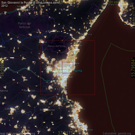
Analysis of San Giovanni la Punta night lights 2016
Square area 10x10 km:
 30.1%
30.1%90-99
35.71%80-89
17.52%70-79
10.88%60-69
3.4%50-59
0%40-49
1.02%30-39
0.51%20-29
0.85%10-19
0%0-9
0%Square area 50x50 km:
4.14%90-99
4.6%80-89
3.5%70-79
3.68%60-69
4%50-59
2.15%40-49
2.19%30-39
3.04%20-29
6.18%10-19
10.85%0-9
55.66%Clear (daylight) street map image can be seen on geolist.org.
Map coordinates:
38° 7' 55.4" North, 14° 23' 26.1" East
37° 34' 36.8" North, 15° 5' 37.4" East
37° 1' 3.3" North, 15° 47' 48.6" East
Some cities around San Giovanni la Punta sort by population:
• Mascalucia
3.9 km =2.4 mi,  266°
266°
• Gravina di Catania
3.2 km =2 mi,  236°
236°
• Tremestieri Etneo
1.9 km =1.2 mi,  224°
224°
• Aci Sant'Antonio
4 km =2.5 mi,  39°
39°
• Trecastagni
4.5 km =2.8 mi,  342°
342°
• Sant'Agata Li Battiati
2.5 km =1.6 mi,  209°
209°
• Canalicchio
4 km =2.5 mi,  176°
176°
• Viagrande
3.7 km =2.3 mi,  5°
5°
2523460 (p: 22,046)
Sources (retrieved 2019-11-25):
» Earth at Night: Flat Maps 2012, 2016