Tremestieri Etneo night lights from space
Night Light of Tremestieri Etneo (Sicily) from space (Italy) Src. Average luminocity for 10x10km area is 92.3523% and for 50x50km: 23.5096%.
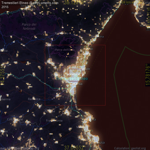
Analysis of Tremestieri Etneo night lights 2016
Square area 10x10 km:
 34.58%
90-99
37.18%80-89
15.91%70-79
8.12%60-69
1.3%50-59
0.32%40-49
1.62%30-39
0.65%20-29
0.32%10-19
0%0-9
0%Square area 50x50 km:
4.06%90-99
4.5%80-89
3.4%70-79
3.54%60-69
3.87%50-59
2.19%40-49
2.14%30-39
3.08%20-29
5.91%10-19
10.87%0-9
56.45%Clear (daylight) street map image can be seen on geolist.org.
Map coordinates:
38° 7' 12.7" North, 14° 22' 31.8" East
37° 33' 53.8" North, 15° 4' 43.1" East
37° 0' 19.9" North, 15° 46' 54.3" East
Some cities around Tremestieri Etneo sort by population:
• Mascalucia
2.8 km =1.7 mi,  292°
292°
• Gravina di Catania
1.5 km =0.9 mi,  251°
251°
• San Giovanni la Punta
1.9 km =1.2 mi,  44°
44°
• Sant'Agata Li Battiati
0.8 km =0.5 mi,  171°
171°
• Canalicchio
3.1 km =1.9 mi,  149°
149°
• San Pietro Clarenza
4.9 km =3 mi,  275°
275°
• Viagrande
5.3 km =3.3 mi,  18°
18°
• San Gregorio di Catania
2.9 km =1.8 mi,  84°
84°
6534257 (p: 13,657)
Sources (retrieved 2019-11-25):
» Earth at Night: Flat Maps 2012, 2016