Pedara night lights from space
Night Light of Pedara (Sicily) from space (Italy) Src. Average luminocity for 10x10km area is 68.3503% and for 50x50km: 24.9013%.
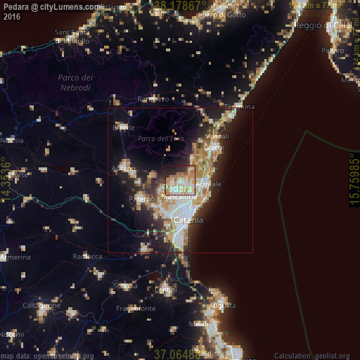
Analysis of Pedara night lights 2016
Square area 10x10 km:
 9.01%
9.01%90-99
18.03%80-89
18.37%70-79
12.41%60-69
14.46%50-59
3.4%40-49
2.21%30-39
3.57%20-29
11.9%10-19
6.46%0-9
0.17%Square area 50x50 km:
4.31%90-99
4.67%80-89
3.75%70-79
3.85%60-69
4.1%50-59
2.25%40-49
2.23%30-39
2.98%20-29
6.44%10-19
11.48%0-9
53.94%Clear (daylight) street map image can be seen on geolist.org.
Map coordinates:
38° 10' 43.2" North, 14° 21' 13" East
37° 37' 25.9" North, 15° 3' 24.2" East
37° 3' 53.6" North, 15° 45' 35.5" East
Some cities around Pedara sort by population:
• Mascalucia
5.5 km =3.4 mi,  186°
186°
• San Giovanni la Punta
6.2 km =3.9 mi,  148°
148°
• Tremestieri Etneo
6.8 km =4.2 mi,  163°
163°
• Aci Sant'Antonio
6.2 km =3.9 mi,  109°
109°
• Trecastagni
2.1 km =1.3 mi,  116°
116°
• Nicolosi
2.6 km =1.6 mi,  264°
264°
• San Pietro Clarenza
6.8 km =4.2 mi,  205°
205°
• Viagrande
3.9 km =2.4 mi, 112°
2523850 (p: 12,089)
Sources (retrieved 2019-11-25):
» Earth at Night: Flat Maps 2012, 2016