San Gregorio di Catania night lights from space
Night Light of San Gregorio di Catania (Sicily) from space (Italy) Src. Average luminocity for 10x10km area is 82.5763% and for 50x50km: 23.1714%.
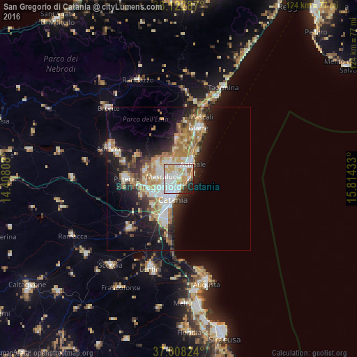
Analysis of San Gregorio di Catania night lights 2016
Square area 10x10 km:
 28.9%
28.9%90-99
28.41%80-89
11.85%70-79
12.18%60-69
4.38%50-59
0.65%40-49
2.92%30-39
1.46%20-29
6.33%10-19
2.92%0-9
0%Square area 50x50 km:
4.05%90-99
4.44%80-89
3.38%70-79
3.54%60-69
3.86%50-59
2.09%40-49
2.11%30-39
2.98%20-29
5.88%10-19
10.44%0-9
57.22%Clear (daylight) street map image can be seen on geolist.org.
Map coordinates:
38° 7' 22.3" North, 14° 24' 29.1" East
37° 34' 3.5" North, 15° 6' 40.3" East
37° 0' 29.7" North, 15° 48' 51.6" East
Some cities around San Gregorio di Catania sort by population:
• Gravina di Catania
4.3 km =2.7 mi,  259°
259°
• Aci Catena
5.1 km =3.2 mi,  32°
32°
• Aci Castello
3.3 km =2.1 mi,  113°
113°
• Tremestieri Etneo
2.9 km =1.8 mi, 264°
• Aci Sant'Antonio
4.3 km =2.7 mi,  13°
13°
• Sant'Agata Li Battiati
3 km =1.9 mi,  247°
247°
• Canalicchio
3.2 km =2 mi,  203°
203°
• Viagrande
4.9 km =3 mi,  346°
346°
2523448 (p: 5,100)
Sources (retrieved 2019-11-25):
» Earth at Night: Flat Maps 2012, 2016