Vetralla night lights from space
Night Light of Vetralla (Latium) from space (Italy) Src. Average luminocity for 10x10km area is 13.2258% and for 50x50km: 9.0204%.
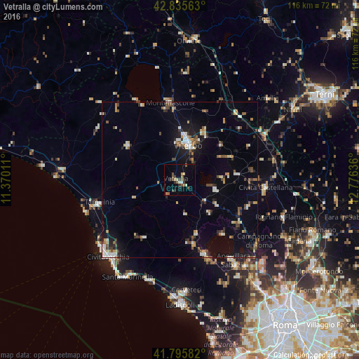
Analysis of Vetralla night lights 2016
Square area 10x10 km:
 0%
0%90-99
1.21%80-89
2.58%70-79
0.76%60-69
1.36%50-59
4.24%40-49
2.58%30-39
2.88%20-29
1.52%10-19
1.36%0-9
81.52%Square area 50x50 km:
0.77%90-99
1.59%80-89
0.87%70-79
0.89%60-69
0.79%50-59
1.24%40-49
1.22%30-39
1.22%20-29
1.64%10-19
5.25%0-9
84.51%Clear (daylight) street map image can be seen on geolist.org.
Map coordinates:
42° 50' 8.3" North, 11° 22' 12.4" East
42° 19' 4.3" North, 12° 4' 23.6" East
41° 47' 45" North, 12° 46' 34.9" East
Some cities around Vetralla sort by population:
• Viterbo
11.6 km =7.2 mi,  13°
13°
• Tuscania
20.2 km =12.6 mi,  303°
303°
• Ronciglione
12.1 km =7.5 mi,  105°
105°
• Nepi
23.8 km =14.8 mi, 110°
• Manziana
21.3 km =13.2 mi,  168°
168°
• Soriano nel Cimino
17.3 km =10.7 mi,  49°
49°
• Capranica
10.5 km =6.5 mi,  128°
128°
• Fabrica di Roma
18.6 km =11.6 mi,  84°
84°
3164472 (p: 11,231)
Sources (retrieved 2019-11-25):
» Earth at Night: Flat Maps 2012, 2016