Tuscania night lights from space
Night Light of Tuscania (Latium) from space (Italy) Src. Average luminocity for 10x10km area is 6.0159% and for 50x50km: 5.7036%.
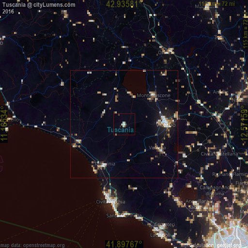
Analysis of Tuscania night lights 2016
Square area 10x10 km:
 1.27%
1.27%90-99
1.27%80-89
1.59%70-79
0%60-69
0.32%50-59
0.32%40-49
0%30-39
1.27%20-29
0.63%10-19
0%0-9
93.33%Square area 50x50 km:
0.41%90-99
1.19%80-89
0.65%70-79
0.56%60-69
0.65%50-59
0.79%40-49
0.71%30-39
0.79%20-29
0.94%10-19
2.97%0-9
90.33%Clear (daylight) street map image can be seen on geolist.org.
Map coordinates:
42° 56' 8.9" North, 11° 9' 55.2" East
42° 25' 8" North, 11° 52' 6.5" East
41° 53' 51.6" North, 12° 34' 17.7" East
Some cities around Tuscania sort by population:
• Viterbo
19.5 km =12.1 mi,  89°
89°
• Tarquinia
20.5 km =12.7 mi,  206°
206°
• Vetralla
20.2 km =12.6 mi,  123°
123°
• Montefiascone
19.2 km =11.9 mi,  44°
44°
• Ronciglione
31.9 km =19.8 mi, 116°
• Soriano nel Cimino
30 km =18.6 mi, 90°
• Capranica
30.7 km =19.1 mi,  125°
125°
• Fabrica di Roma
36.6 km =22.7 mi,  104°
104°
3165083 (p: 7,226)
Sources (retrieved 2019-11-25):
» Earth at Night: Flat Maps 2012, 2016