Manziana night lights from space
Night Light of Manziana (Latium) from space (Italy) Src. Average luminocity for 10x10km area is 16.4864% and for 50x50km: 14.8498%.
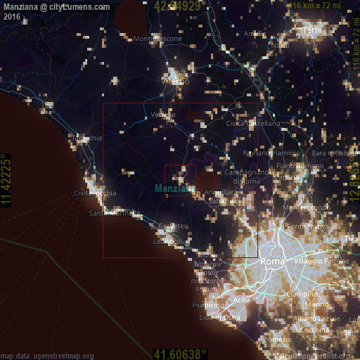
Analysis of Manziana night lights 2016
Square area 10x10 km:
 1.52%
1.52%90-99
2.73%80-89
1.06%70-79
3.48%60-69
1.21%50-59
3.03%40-49
2.88%30-39
2.58%20-29
1.36%10-19
7.42%0-9
72.73%Square area 50x50 km:
1.79%90-99
2.73%80-89
1.81%70-79
1.34%60-69
1.5%50-59
1.97%40-49
2.05%30-39
2.16%20-29
3.39%10-19
10.11%0-9
71.15%Clear (daylight) street map image can be seen on geolist.org.
Map coordinates:
42° 38' 57.4" North, 11° 25' 20.1" East
42° 7' 47.9" North, 12° 7' 31.3" East
41° 36' 23" North, 12° 49' 42.6" East
Some cities around Manziana sort by population:
• Ladispoli
20.4 km =12.7 mi,  191°
191°
• Cerveteri
15.7 km =9.8 mi, 190°
• Anguillara Sabazia
14.2 km =8.8 mi,  113°
113°
• Bracciano
4.5 km =2.8 mi,  132°
132°
• Marina di Cerveteri
17.7 km =11 mi,  199°
199°
• Ronciglione
19.2 km =11.9 mi,  22°
22°
• Cesano
18.6 km =11.6 mi, 109°
• Capranica
14.8 km =9.2 mi, 15°
3174043 (p: 6,125)
Sources (retrieved 2019-11-25):
» Earth at Night: Flat Maps 2012, 2016