Ronciglione night lights from space
Night Light of Ronciglione (Latium) from space (Italy) Src. Average luminocity for 10x10km area is 15.2636% and for 50x50km: 11.6487%.
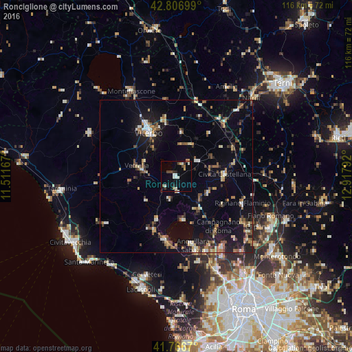
Analysis of Ronciglione night lights 2016
Square area 10x10 km:
 1.36%
1.36%90-99
4.39%80-89
1.36%70-79
0.61%60-69
1.36%50-59
0.61%40-49
3.03%30-39
1.97%20-29
1.21%10-19
3.33%0-9
80.76%Square area 50x50 km:
0.75%90-99
1.74%80-89
1.35%70-79
1.2%60-69
1.26%50-59
1.87%40-49
1.51%30-39
1.5%20-29
2.52%10-19
7.98%0-9
78.32%Clear (daylight) street map image can be seen on geolist.org.
Map coordinates:
42° 48' 25.2" North, 11° 30' 42" East
42° 17' 20.4" North, 12° 12' 53.2" East
41° 46' 0.1" North, 12° 55' 4.5" East
Some cities around Ronciglione sort by population:
• Viterbo
17 km =10.6 mi,  328°
328°
• Civita Castellana
16 km =9.9 mi,  88°
88°
• Vetralla
12.1 km =7.5 mi,  285°
285°
• Nepi
11.8 km =7.3 mi,  116°
116°
• Manziana
19.2 km =11.9 mi,  202°
202°
• Soriano nel Cimino
14.5 km =9 mi,  6°
6°
• Capranica
4.8 km =3 mi,  225°
225°
• Fabrica di Roma
8.6 km =5.3 mi,  53°
53°
3169012 (p: 7,211)
Sources (retrieved 2019-11-25):
» Earth at Night: Flat Maps 2012, 2016