Vernio night lights from space
Night Light of Vernio (Tuscany) from space (Italy) Src. Average luminocity for 10x10km area is 3.027% and for 50x50km: 14.1995%.
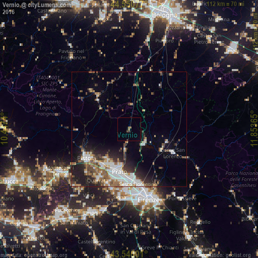
Analysis of Vernio night lights 2016
Square area 10x10 km:
 0%
0%90-99
0%80-89
0%70-79
0%60-69
1.11%50-59
0.79%40-49
0.63%30-39
0.95%20-29
0%10-19
0.16%0-9
96.35%Square area 50x50 km:
2.78%90-99
2.57%80-89
1.02%70-79
1.27%60-69
1.75%50-59
2.45%40-49
2.29%30-39
2.06%20-29
3.81%10-19
5.99%0-9
74.02%Clear (daylight) street map image can be seen on geolist.org.
Map coordinates:
44° 33' 2.8" North, 10° 26' 50.6" East
44° 2' 51.2" North, 11° 9' 1.9" East
43° 32' 24" North, 11° 51' 13.1" East
Some cities around Vernio sort by population:
• Prato
19.1 km =11.9 mi,  192°
192°
• Montemurlo
16.2 km =10.1 mi,  214°
214°
• Fornacelle
16.6 km =10.3 mi, 213°
• Agliana
19.9 km =12.4 mi,  215°
215°
• Vaiano
9.1 km =5.7 mi, 193°
• Montale
16.5 km =10.3 mi, 220°
• Barberino di Mugello
8.7 km =5.4 mi,  127°
127°
• Scarperia
17.4 km =10.8 mi,  110°
110°
3164533 (p: 5,535)
Sources (retrieved 2019-11-25):
» Earth at Night: Flat Maps 2012, 2016