Montale night lights from space
Night Light of Montale (Tuscany) from space (Italy) Src. Average luminocity for 10x10km area is 47.8603% and for 50x50km: 27.2179%.
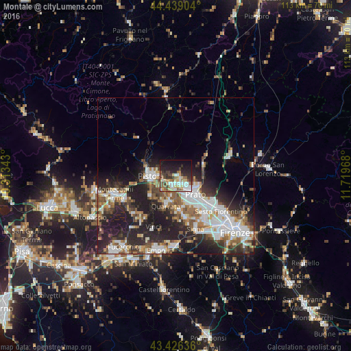
Analysis of Montale night lights 2016
Square area 10x10 km:
 9.52%
9.52%90-99
8.25%80-89
6.51%70-79
5.08%60-69
5.4%50-59
8.89%40-49
7.14%30-39
7.94%20-29
13.81%10-19
21.11%0-9
6.35%Square area 50x50 km:
5.97%90-99
5.75%80-89
2.04%70-79
2.43%60-69
3.33%50-59
3.84%40-49
3.95%30-39
3.81%20-29
9.64%10-19
12.09%0-9
47.15%Clear (daylight) street map image can be seen on geolist.org.
Map coordinates:
44° 26' 20.5" North, 10° 18' 48.3" East
43° 56' 5.5" North, 11° 0' 59.6" East
43° 25' 34.9" North, 11° 43' 10.8" East
Some cities around Montale sort by population:
• Prato
8.8 km =5.5 mi,  133°
133°
• Pistoia
7.5 km =4.7 mi,  266°
266°
• Montemurlo
1.9 km =1.2 mi,  118°
118°
• Fornacelle
1.9 km =1.2 mi, 129°
• Agliana
3.7 km =2.3 mi,  194°
194°
• Quarrata
10.1 km =6.3 mi,  197°
197°
• Vaiano
9.3 km =5.8 mi,  66°
66°
• Cantagrillo-Casalguidi
11 km =6.8 mi,  228°
228°
3173093 (p: 6,316)
Sources (retrieved 2019-11-25):
» Earth at Night: Flat Maps 2012, 2016