Scarperia night lights from space
Night Light of Scarperia (Tuscany) from space (Italy) Src. Average luminocity for 10x10km area is 16.1175% and for 50x50km: 13.0313%.
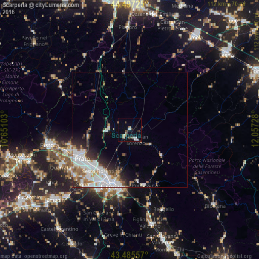
Analysis of Scarperia night lights 2016
Square area 10x10 km:
 3.17%
3.17%90-99
3.81%80-89
0.95%70-79
0.63%60-69
0.48%50-59
3.49%40-49
3.02%30-39
0.63%20-29
1.27%10-19
4.44%0-9
78.1%Square area 50x50 km:
3.91%90-99
3.25%80-89
0.74%70-79
0.96%60-69
1.22%50-59
1.66%40-49
1.13%30-39
1.47%20-29
2.45%10-19
3.11%0-9
80.09%Clear (daylight) street map image can be seen on geolist.org.
Map coordinates:
44° 29' 50.1" North, 10° 39' 3.7" East
43° 59' 36.9" North, 11° 21' 14.9" East
43° 29' 8.1" North, 12° 3' 26.2" East
Some cities around Scarperia sort by population:
• Prato
24.1 km =15 mi,  238°
238°
• Sesto Fiorentino
21.8 km =13.5 mi,  214°
214°
• Calenzano
21.6 km =13.4 mi,  224°
224°
• Pontassieve
25.1 km =15.6 mi,  165°
165°
• Borgo San Lorenzo
4.9 km =3 mi,  149°
149°
• Vaiano
18.7 km =11.6 mi,  261°
261°
• Barberino di Mugello
9.4 km =5.8 mi,  273°
273°
• Vernio
17.4 km =10.8 mi,  290°
290°
3166955 (p: 5,163)
Sources (retrieved 2019-11-25):
» Earth at Night: Flat Maps 2012, 2016