Agliana night lights from space
Night Light of Agliana (Tuscany) from space (Italy) Src. Average luminocity for 10x10km area is 67.7143% and for 50x50km: 29.6533%.
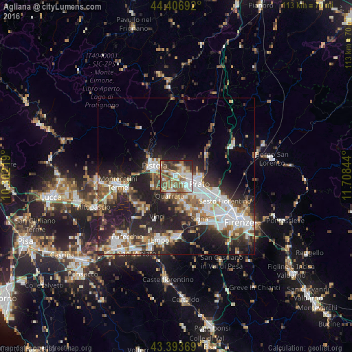
Analysis of Agliana night lights 2016
Square area 10x10 km:
 14.76%
90-99
14.6%80-89
7.78%70-79
8.1%60-69
10.48%50-59
18.41%40-49
11.27%30-39
6.83%20-29
7.62%10-19
0.16%0-9
0%Square area 50x50 km:
6.47%90-99
6.22%80-89
2.29%70-79
2.69%60-69
3.56%50-59
4.25%40-49
4.37%30-39
4.01%20-29
10.55%10-19
13.7%0-9
41.89%Clear (daylight) street map image can be seen on geolist.org.
Map coordinates:
44° 24' 24.9" North, 10° 18' 7.9" East
43° 54' 8.9" North, 11° 0' 19.1" East
43° 23' 37.3" North, 11° 42' 30.4" East
Some cities around Agliana sort by population:
• Prato
7.7 km =4.8 mi,  108°
108°
• Pistoia
7.3 km =4.5 mi,  295°
295°
• Montemurlo
3.7 km =2.3 mi,  43°
43°
• Fornacelle
3.4 km =2.1 mi,  45°
45°
• Quarrata
6.4 km =4 mi,  199°
199°
• Cantagrillo-Casalguidi
8.2 km =5.1 mi,  243°
243°
• Montale
3.7 km =2.3 mi,  14°
14°
• Seano
8.1 km =5 mi,  170°
170°
3183441 (p: 14,561)
Sources (retrieved 2019-11-25):
» Earth at Night: Flat Maps 2012, 2016