Fornacelle night lights from space
Night Light of Fornacelle (Tuscany) from space (Italy) Src. Average luminocity for 10x10km area is 54.8762% and for 50x50km: 27.615%.
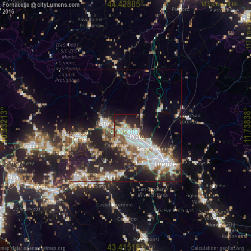
Analysis of Fornacelle night lights 2016
Square area 10x10 km:
 15.4%
15.4%90-99
10.32%80-89
6.35%70-79
5.08%60-69
6.67%50-59
8.57%40-49
4.92%30-39
7.94%20-29
14.13%10-19
19.84%0-9
0.79%Square area 50x50 km:
6.06%90-99
5.87%80-89
1.99%70-79
2.4%60-69
3.36%50-59
3.98%40-49
4.02%30-39
3.83%20-29
9.69%10-19
12.69%0-9
46.11%Clear (daylight) street map image can be seen on geolist.org.
Map coordinates:
44° 25' 41" North, 10° 19' 55.7" East
43° 55' 25.6" North, 11° 2' 6.9" East
43° 24' 54.6" North, 11° 44' 18.2" East
Some cities around Fornacelle sort by population:
• Prato
6.9 km =4.3 mi,  134°
134°
• Pistoia
9 km =5.6 mi,  274°
274°
• Montemurlo
0.4 km =0.2 mi,  24°
24°
• Agliana
3.4 km =2.1 mi,  225°
225°
• Quarrata
9.5 km =5.9 mi,  208°
208°
• Vaiano
8.6 km =5.3 mi,  55°
55°
• Montale
1.9 km =1.2 mi,  309°
309°
• Seano
10.4 km =6.5 mi,  186°
186°
3176722 (p: 17,278)
Sources (retrieved 2019-11-25):
» Earth at Night: Flat Maps 2012, 2016