Vaiano night lights from space
Night Light of Vaiano (Tuscany) from space (Italy) Src. Average luminocity for 10x10km area is 13.9143% and for 50x50km: 22.2269%.
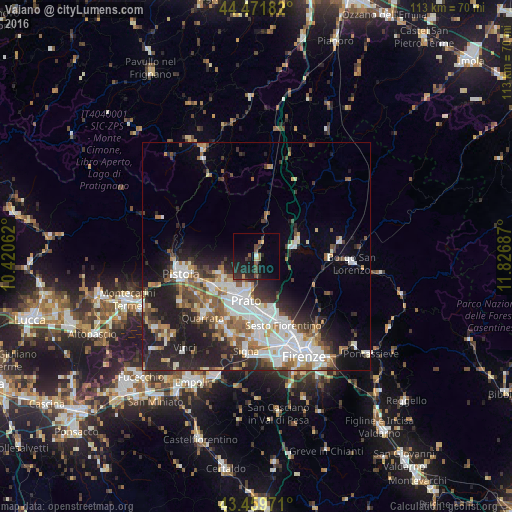
Analysis of Vaiano night lights 2016
Square area 10x10 km:
 0%
0%90-99
0.63%80-89
1.43%70-79
0.48%60-69
1.27%50-59
3.17%40-49
2.22%30-39
3.17%20-29
9.68%10-19
16.83%0-9
61.11%Square area 50x50 km:
5.05%90-99
4.8%80-89
1.48%70-79
1.94%60-69
2.67%50-59
3.3%40-49
2.71%30-39
2.82%20-29
6.99%10-19
9.6%0-9
58.65%Clear (daylight) street map image can be seen on geolist.org.
Map coordinates:
44° 28' 18.6" North, 10° 25' 14.2" East
43° 58' 4.5" North, 11° 7' 25.5" East
43° 27' 35" North, 11° 49' 36.7" East
Some cities around Vaiano sort by population:
• Prato
10 km =6.2 mi,  192°
192°
• Montemurlo
8.3 km =5.2 mi,  236°
236°
• Fornacelle
8.6 km =5.3 mi, 235°
• Agliana
12 km =7.5 mi,  232°
232°
• Calenzano
13.1 km =8.1 mi,  164°
164°
• Montale
9.3 km =5.8 mi,  246°
246°
• Barberino di Mugello
9.7 km =6 mi,  68°
68°
• Vernio
9.1 km =5.7 mi,  13°
13°
3164973 (p: 8,243)
Sources (retrieved 2019-11-25):
» Earth at Night: Flat Maps 2012, 2016