Martinengo night lights from space
Night Light of Martinengo (Lombardy) from space (Italy) Src. Average luminocity for 10x10km area is 54.3242% and for 50x50km: 49.9714%.
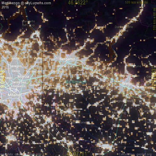
Analysis of Martinengo night lights 2016
Square area 10x10 km:
 9.39%
9.39%90-99
9.24%80-89
5.76%70-79
2.58%60-69
7.42%50-59
9.09%40-49
14.09%30-39
24.39%20-29
18.03%10-19
0%0-9
0%Square area 50x50 km:
9.63%90-99
10.74%80-89
4.83%70-79
5.53%60-69
7.44%50-59
8.09%40-49
7.22%30-39
8.48%20-29
15.08%10-19
16.58%0-9
6.39%Clear (daylight) street map image can be seen on geolist.org.
Map coordinates:
46° 3' 43.9" North, 9° 3' 51.8" East
45° 34' 19.8" North, 9° 46' 3" East
45° 4' 40.1" North, 10° 28' 14.3" East
Some cities around Martinengo sort by population:
• Romano di Lombardia
5.8 km =3.6 mi,  190°
190°
• Cologno al Serio
4.6 km =2.9 mi,  275°
275°
• Urgnano
6.4 km =4 mi,  298°
298°
• Pontoglio
6.7 km =4.2 mi,  92°
92°
• Ghisalba
2.5 km =1.6 mi,  342°
342°
• Bolgare
7.6 km =4.7 mi,  28°
28°
• Palosco
5.7 km =3.5 mi,  70°
70°
• Calcinate
5.8 km =3.6 mi,  24°
24°
3173839 (p: 8,922)
Sources (retrieved 2019-11-25):
» Earth at Night: Flat Maps 2012, 2016