Ghisalba night lights from space
Night Light of Ghisalba (Lombardy) from space (Italy) Src. Average luminocity for 10x10km area is 59.2015% and for 50x50km: 49.8985%.
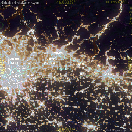
Analysis of Ghisalba night lights 2016
Square area 10x10 km:
 11.06%
90-99
11.06%80-89
5.91%70-79
3.18%60-69
8.94%50-59
13.03%40-49
17.58%30-39
19.7%20-29
9.55%10-19
0%0-9
0%Square area 50x50 km:
9.55%90-99
10.62%80-89
4.79%70-79
5.57%60-69
7.55%50-59
8.2%40-49
7.38%30-39
8.43%20-29
14.63%10-19
17.05%0-9
6.22%Clear (daylight) street map image can be seen on geolist.org.
Map coordinates:
46° 5' 0.2" North, 9° 3' 16.3" East
45° 35' 36.7" North, 9° 45' 27.5" East
45° 5' 57.8" North, 10° 27' 38.8" East
Some cities around Ghisalba sort by population:
• Cologno al Serio
4.3 km =2.7 mi,  242°
242°
• Martinengo
2.5 km =1.6 mi,  162°
162°
• Urgnano
4.9 km =3 mi,  277°
277°
• Grassobbio
7.5 km =4.7 mi,  340°
340°
• Spirano
7.1 km =4.4 mi,  259°
259°
• Bolgare
6.2 km =3.9 mi,  45°
45°
• Palosco
6.2 km =3.9 mi,  94°
94°
• Calcinate
4.3 km =2.7 mi, 47°
3176163 (p: 5,786)
Sources (retrieved 2019-11-25):
» Earth at Night: Flat Maps 2012, 2016