Uboldo night lights from space
Night Light of Uboldo (Lombardy) from space (Italy) Src. Average luminocity for 10x10km area is 88.7515% and for 50x50km: 74.9334%.
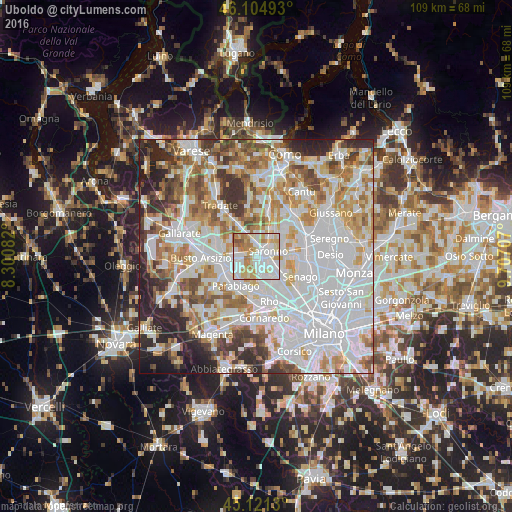
Analysis of Uboldo night lights 2016
Square area 10x10 km:
 31.21%
90-99
28.64%80-89
14.09%70-79
11.67%60-69
11.36%50-59
2.42%40-49
0.61%30-39
0%20-29
0%10-19
0%0-9
0%Square area 50x50 km:
28.18%90-99
19.03%80-89
7.23%70-79
8.39%60-69
9.11%50-59
6.15%40-49
5.63%30-39
5.61%20-29
7.37%10-19
3.19%0-9
0.11%Clear (daylight) street map image can be seen on geolist.org.
Map coordinates:
46° 6' 17.7" North, 8° 18' 3" East
45° 36' 55" North, 9° 0' 14.2" East
45° 7' 16.7" North, 9° 42' 25.5" East
Some cities around Uboldo sort by population:
• Saronno
2.7 km =1.7 mi,  65°
65°
• Caronno Pertusella
3.8 km =2.4 mi,  120°
120°
• Rescaldina
4.3 km =2.7 mi,  277°
277°
• Cerro Maggiore
4.5 km =2.8 mi,  238°
238°
• Gerenzano
2.7 km =1.7 mi,  355°
355°
• Turate
4.7 km =2.9 mi,  0°
0°
• Origgio
2.3 km =1.4 mi,  154°
154°
• Rovello Porro
4.9 km =3 mi,  33°
33°
6534237 (p: 9,762)
Sources (retrieved 2019-11-25):
» Earth at Night: Flat Maps 2012, 2016