Caronno Pertusella night lights from space
Night Light of Caronno Pertusella (Lombardy) from space (Italy) Src. Average luminocity for 10x10km area is 92.8652% and for 50x50km: 76.8908%.
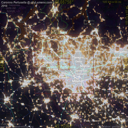
Analysis of Caronno Pertusella night lights 2016
Square area 10x10 km:
 38.79%
90-99
32.42%80-89
13.33%70-79
12.12%60-69
3.33%50-59
0%40-49
0%30-39
0%20-29
0%10-19
0%0-9
0%Square area 50x50 km:
29.09%90-99
19.63%80-89
7.55%70-79
8.65%60-69
9.74%50-59
6.76%40-49
5.85%30-39
5.29%20-29
4.83%10-19
2.31%0-9
0.29%Clear (daylight) street map image can be seen on geolist.org.
Map coordinates:
46° 5' 15.3" North, 8° 20' 35.6" East
45° 35' 52" North, 9° 2' 46.8" East
45° 6' 13.1" North, 9° 44' 58.1" East
Some cities around Caronno Pertusella sort by population:
• Saronno
3.2 km =2 mi,  344°
344°
• Garbagnate Milanese
3.4 km =2.1 mi,  139°
139°
• Lainate
3.3 km =2.1 mi,  207°
207°
• Cesate
2.3 km =1.4 mi,  95°
95°
• Solaro
3.4 km =2.1 mi,  57°
57°
• Uboldo
3.8 km =2.4 mi,  300°
300°
• Origgio
2.3 km =1.4 mi,  267°
267°
• Ceriano Laghetto
4.4 km =2.7 mi,  36°
36°
6534234 (p: 16,377)
Sources (retrieved 2019-11-25):
» Earth at Night: Flat Maps 2012, 2016