Cerro Maggiore night lights from space
Night Light of Cerro Maggiore (Lombardy) from space (Italy) Src. Average luminocity for 10x10km area is 91.2379% and for 50x50km: 70.6206%.
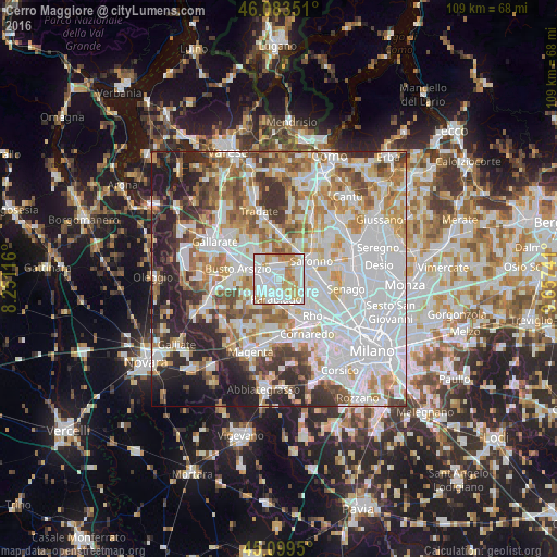
Analysis of Cerro Maggiore night lights 2016
Square area 10x10 km:
 38.94%
90-99
30.3%80-89
8.64%70-79
12.58%60-69
8.64%50-59
0.91%40-49
0%30-39
0%20-29
0%10-19
0%0-9
0%Square area 50x50 km:
26.02%90-99
17.11%80-89
6.64%70-79
7.81%60-69
8.65%50-59
6.1%40-49
5.74%30-39
5.81%20-29
8.9%10-19
6.18%0-9
1.03%Clear (daylight) street map image can be seen on geolist.org.
Map coordinates:
46° 5' 0.6" North, 8° 15' 4.2" East
45° 35' 37.2" North, 8° 57' 15.4" East
45° 5' 58.2" North, 9° 39' 26.7" East
Some cities around Cerro Maggiore sort by population:
• Legnano
3.1 km =1.9 mi,  278°
278°
• Parabiago
3.8 km =2.4 mi,  190°
190°
• Rescaldina
3 km =1.9 mi,  351°
351°
• Canegrate
3.5 km =2.2 mi,  217°
217°
• Uboldo
4.5 km =2.8 mi,  58°
58°
• San Vittore Olona
1.3 km =0.8 mi,  228°
228°
• Origgio
4.8 km =3 mi,  85°
85°
• San Giorgio Su Legnano
3.9 km =2.4 mi, 234°
3179027 (p: 12,027)
Sources (retrieved 2019-11-25):
» Earth at Night: Flat Maps 2012, 2016