Gerenzano night lights from space
Night Light of Gerenzano (Lombardy) from space (Italy) Src. Average luminocity for 10x10km area is 84.6% and for 50x50km: 74.1951%.
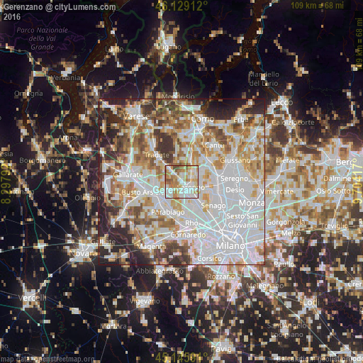
Analysis of Gerenzano night lights 2016
Square area 10x10 km:
100  25.15%
90-99 25.61%
80-89 12.88%
70-79 13.03%
60-69 15.15%
50-59 5.45%
40-49 2.73%
30-39 0%
20-29 0%
10-19 0%
0-9 0%
25.15%90-99
25.61%80-89
12.88%70-79
13.03%60-69
15.15%50-59
5.45%40-49
2.73%30-39
0%20-29
0%10-19
0%0-9
0%Square area 50x50 km:
100 27.69%
90-99 18.6%
80-89 7.11%
70-79 8.48%
60-69 9.01%
50-59 6.25%
40-49 5.61%
30-39 5.71%
20-29 8.08%
10-19 3.17%
0-9 0.29%
27.69%90-99
18.6%80-89
7.11%70-79
8.48%60-69
9.01%50-59
6.25%40-49
5.61%30-39
5.71%20-29
8.08%10-19
3.17%0-9
0.29%Clear (daylight) street map image can be seen on geolist.org.
Map coordinates:
46° 7' 44.8" North, 8° 17' 52.5" East
45° 38' 22.8" North, 9° 0' 3.7" East
45° 8' 45.3" North, 9° 42' 15" East
Some cities around Gerenzano sort by population:
• Saronno
3.1 km =1.9 mi,  121°
121°
• Rescaldina
4.6 km =2.9 mi,  241°
241°
• Uboldo
2.7 km =1.7 mi,  175°
175°
• Cislago
3.1 km =1.9 mi,  314°
314°
• Turate
2 km =1.2 mi,  7°
7°
• Rovellasca
4.8 km =3 mi,  51°
51°
• Origgio
4.9 km =3 mi,  165°
165°
• Rovello Porro
3.3 km =2.1 mi,  65°
65°
6534236 (p: 9,835)
Sources (retrieved 2019-11-25):
» Earth at Night: Flat Maps 2012, 2016