Rescaldina night lights from space
Night Light of Rescaldina (Lombardy) from space (Italy) Src. Average luminocity for 10x10km area is 87.8167% and for 50x50km: 71.0141%.
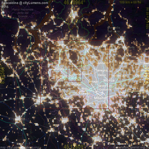
Analysis of Rescaldina night lights 2016
Square area 10x10 km:
 33.18%
90-99
26.97%80-89
9.39%70-79
12.27%60-69
13.79%50-59
3.79%40-49
0.61%30-39
0%20-29
0%10-19
0%0-9
0%Square area 50x50 km:
25.76%90-99
17.24%80-89
6.6%70-79
7.97%60-69
8.68%50-59
6.33%40-49
6.08%30-39
6.34%20-29
9.18%10-19
5.74%0-9
0.07%Clear (daylight) street map image can be seen on geolist.org.
Map coordinates:
46° 6' 34.7" North, 8° 14' 44.4" East
45° 37' 12.1" North, 8° 56' 55.6" East
45° 7' 33.9" North, 9° 39' 6.9" East
Some cities around Rescaldina sort by population:
• Legnano
3.6 km =2.2 mi,  226°
226°
• Castellanza
4.2 km =2.6 mi,  255°
255°
• Cerro Maggiore
3 km =1.9 mi,  171°
171°
• Gerenzano
4.6 km =2.9 mi,  61°
61°
• Uboldo
4.3 km =2.7 mi,  97°
97°
• Gorla Minore
4.3 km =2.7 mi,  303°
303°
• San Vittore Olona
3.9 km =2.4 mi,  188°
188°
• Marnate
3.2 km =2 mi,  287°
287°
3169481 (p: 13,911)
Sources (retrieved 2019-11-25):
» Earth at Night: Flat Maps 2012, 2016