Turate night lights from space
Night Light of Turate (Lombardy) from space (Italy) Src. Average luminocity for 10x10km area is 80.6258% and for 50x50km: 72.8155%.
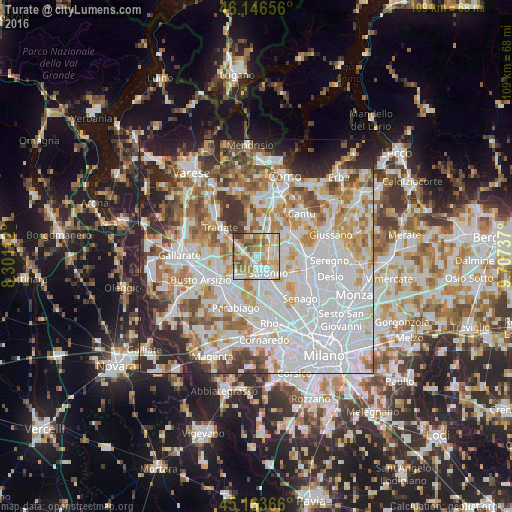
Analysis of Turate night lights 2016
Square area 10x10 km:
100  19.39%
90-99 21.52%
80-89 14.55%
70-79 15%
60-69 16.06%
50-59 7.58%
40-49 3.79%
30-39 2.12%
20-29 0%
10-19 0%
0-9 0%
19.39%90-99
21.52%80-89
14.55%70-79
15%60-69
16.06%50-59
7.58%40-49
3.79%30-39
2.12%20-29
0%10-19
0%0-9
0%Square area 50x50 km:
100 27.06%
90-99 18.1%
80-89 6.96%
70-79 8.21%
60-69 8.89%
50-59 6.25%
40-49 5.56%
30-39 5.68%
20-29 8.21%
10-19 4.03%
0-9 1.05%
27.06%90-99
18.1%80-89
6.96%70-79
8.21%60-69
8.89%50-59
6.25%40-49
5.56%30-39
5.68%20-29
8.21%10-19
4.03%0-9
1.05%Clear (daylight) street map image can be seen on geolist.org.
Map coordinates:
46° 8' 47.6" North, 8° 18' 4" East
45° 39' 26.2" North, 9° 0' 15.3" East
45° 9' 49.2" North, 9° 42' 26.5" East
Some cities around Turate sort by population:
• Saronno
4.3 km =2.7 mi,  146°
146°
• Gerenzano
2 km =1.2 mi,  187°
187°
• Uboldo
4.7 km =2.9 mi,  180°
180°
• Cislago
2.5 km =1.6 mi,  275°
275°
• Mozzate
4.2 km =2.6 mi,  297°
297°
• Lomazzo
5 km =3.1 mi,  28°
28°
• Rovellasca
3.6 km =2.2 mi,  73°
73°
• Rovello Porro
2.8 km =1.7 mi,  101°
101°
6535757 (p: 8,581)
Sources (retrieved 2019-11-25):
» Earth at Night: Flat Maps 2012, 2016