Cislago night lights from space
Night Light of Cislago (Lombardy) from space (Italy) Src. Average luminocity for 10x10km area is 77.1424% and for 50x50km: 70.3612%.
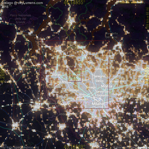
Analysis of Cislago night lights 2016
Square area 10x10 km:
 14.85%
90-99
19.09%80-89
12.27%70-79
16.06%60-69
19.09%50-59
10.76%40-49
4.39%30-39
3.48%20-29
0%10-19
0%0-9
0%Square area 50x50 km:
25.73%90-99
16.94%80-89
6.62%70-79
7.85%60-69
8.56%50-59
6.29%40-49
5.84%30-39
6.11%20-29
9.34%10-19
5.38%0-9
1.33%Clear (daylight) street map image can be seen on geolist.org.
Map coordinates:
46° 8' 54.8" North, 8° 16' 10.6" East
45° 39' 33.4" North, 8° 58' 21.8" East
45° 9' 56.5" North, 9° 40' 33.1" East
Some cities around Cislago sort by population:
• Rescaldina
4.7 km =2.9 mi,  203°
203°
• Gerenzano
3.1 km =1.9 mi,  134°
134°
• Uboldo
5.5 km =3.4 mi,  153°
153°
• Turate
2.5 km =1.6 mi,  95°
95°
• Gorla Minore
5.8 km =3.6 mi,  249°
249°
• Mozzate
2.1 km =1.3 mi,  323°
323°
• Rovellasca
6 km =3.7 mi,  82°
82°
• Rovello Porro
5.2 km =3.2 mi, 98°
3178640 (p: 8,997)
Sources (retrieved 2019-11-25):
» Earth at Night: Flat Maps 2012, 2016