Mozzate night lights from space
Night Light of Mozzate (Lombardy) from space (Italy) Src. Average luminocity for 10x10km area is 73.7545% and for 50x50km: 67.8773%.
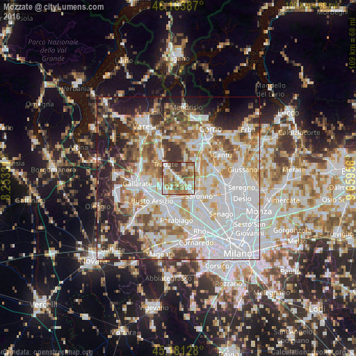
Analysis of Mozzate night lights 2016
Square area 10x10 km:
 13.64%
90-99
17.58%80-89
9.7%70-79
13.03%60-69
20.91%50-59
11.82%40-49
5.61%30-39
7.73%20-29
0%10-19
0%0-9
0%Square area 50x50 km:
24.27%90-99
16.15%80-89
6.27%70-79
7.46%60-69
8.49%50-59
6.4%40-49
6.01%30-39
5.93%20-29
9.33%10-19
7.32%0-9
2.36%Clear (daylight) street map image can be seen on geolist.org.
Map coordinates:
46° 9' 49.9" North, 8° 15' 11.9" East
45° 40' 29" North, 8° 57' 23.2" East
45° 10' 52.6" North, 9° 39' 34.4" East
Some cities around Mozzate sort by population:
• Tradate
5.3 km =3.3 mi,  314°
314°
• Rescaldina
6.1 km =3.8 mi,  185°
185°
• Gerenzano
5.2 km =3.2 mi,  138°
138°
• Cislago
2.1 km =1.3 mi, 143°
• Turate
4.2 km =2.6 mi,  117°
117°
• Gorla Minore
5.6 km =3.5 mi,  228°
228°
• Marnate
6.3 km =3.9 mi,  215°
215°
• Gorla Maggiore
4.9 km =3 mi,  255°
255°
3172495 (p: 8,204)
Sources (retrieved 2019-11-25):
» Earth at Night: Flat Maps 2012, 2016