Rovellasca night lights from space
Night Light of Rovellasca (Lombardy) from space (Italy) Src. Average luminocity for 10x10km area is 87.3773% and for 50x50km: 73.6411%.
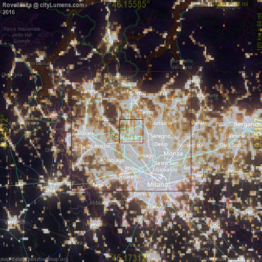
Analysis of Rovellasca night lights 2016
Square area 10x10 km:
 26.36%
90-99
28.33%80-89
17.58%70-79
13.64%60-69
10.76%50-59
1.97%40-49
1.36%30-39
0%20-29
0%10-19
0%0-9
0%Square area 50x50 km:
27.31%90-99
18.43%80-89
7.11%70-79
8.48%60-69
9.45%50-59
6.6%40-49
5.71%30-39
5.25%20-29
5.75%10-19
4.18%0-9
1.73%Clear (daylight) street map image can be seen on geolist.org.
Map coordinates:
46° 9' 21.1" North, 8° 20' 44.6" East
45° 39' 59.9" North, 9° 2' 55.8" East
45° 10' 23.2" North, 9° 45' 7.1" East
Some cities around Rovellasca sort by population:
• Saronno
4.7 km =2.9 mi,  192°
192°
• Cermenate
4.8 km =3 mi,  34°
34°
• Turate
3.6 km =2.2 mi,  253°
253°
• Cogliate
3.3 km =2.1 mi,  134°
134°
• Lomazzo
3.5 km =2.2 mi,  341°
341°
• Lazzate
2.8 km =1.7 mi,  77°
77°
• Bregnano
3.6 km =2.2 mi,  13°
13°
• San Michele-San Giorgio
3.3 km =2.1 mi, 13°
3168870 (p: 7,539)
Sources (retrieved 2019-11-25):
» Earth at Night: Flat Maps 2012, 2016