Bonate Sopra night lights from space
Night Light of Bonate Sopra (Lombardy) from space (Italy) Src. Average luminocity for 10x10km area is 84.5% and for 50x50km: 57.1542%.
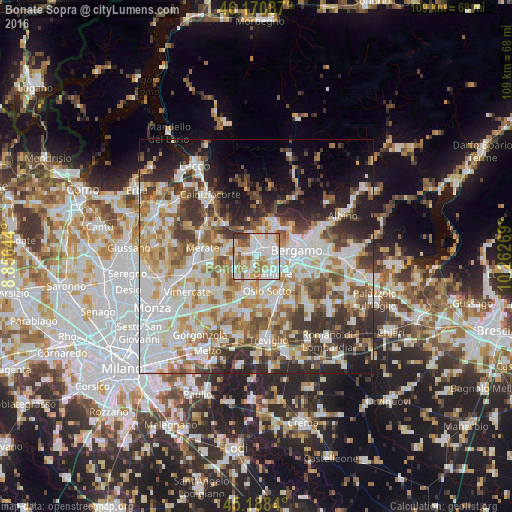
Analysis of Bonate Sopra night lights 2016
Square area 10x10 km:
 29.24%
90-99
27.73%80-89
6.36%70-79
12.27%60-69
13.03%50-59
6.06%40-49
1.82%30-39
3.48%20-29
0%10-19
0%0-9
0%Square area 50x50 km:
15.3%90-99
13.87%80-89
5.56%70-79
7.15%60-69
8.02%50-59
7.05%40-49
6.6%30-39
7.56%20-29
8.96%10-19
8.84%0-9
11.09%Clear (daylight) street map image can be seen on geolist.org.
Map coordinates:
46° 10' 15.1" North, 8° 51' 23.2" East
45° 40' 54.4" North, 9° 33' 34.4" East
45° 11' 18.2" North, 10° 15' 45.7" East
Some cities around Bonate Sopra sort by population:
• Dalmine
5.1 km =3.2 mi,  134°
134°
• Ponte San Pietro
3.6 km =2.2 mi,  41°
41°
• Treviolo
4.2 km =2.6 mi,  102°
102°
• Brembate di Sopra
4.2 km =2.6 mi,  21°
21°
• Terno d'Isola
2.3 km =1.4 mi,  280°
280°
• Curno
3.9 km =2.4 mi,  78°
78°
• Mozzo
4.3 km =2.7 mi,  63°
63°
• Bottanuco
6.1 km =3.8 mi,  219°
219°
3181896 (p: 7,060)
Sources (retrieved 2019-11-25):
» Earth at Night: Flat Maps 2012, 2016