Mozzo night lights from space
Night Light of Mozzo (Lombardy) from space (Italy) Src. Average luminocity for 10x10km area is 88.3803% and for 50x50km: 53.2478%.
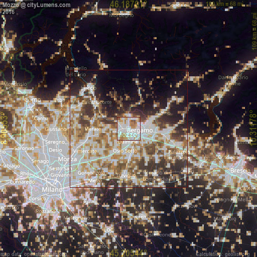
Analysis of Mozzo night lights 2016
Square area 10x10 km:
 33.48%
90-99
31.36%80-89
7.58%70-79
11.52%60-69
9.24%50-59
4.24%40-49
2.58%30-39
0%20-29
0%10-19
0%0-9
0%Square area 50x50 km:
12.69%90-99
13.21%80-89
5.22%70-79
6.43%60-69
7.68%50-59
7.26%40-49
6.7%30-39
7.89%20-29
8.44%10-19
9.93%0-9
14.54%Clear (daylight) street map image can be seen on geolist.org.
Map coordinates:
46° 11' 15.4" North, 8° 54' 19.9" East
45° 41' 55.2" North, 9° 36' 31.1" East
45° 12' 19.6" North, 10° 18' 42.4" East
Some cities around Mozzo sort by population:
• Bergamo
4.6 km =2.9 mi,  93°
93°
• Ponte San Pietro
1.6 km =1 mi,  299°
299°
• Treviolo
2.8 km =1.7 mi,  174°
174°
• Sorisole
4.3 km =2.7 mi,  31°
31°
• Brembate di Sopra
3 km =1.9 mi,  311°
311°
• Curno
1.1 km =0.7 mi,  179°
179°
• Bonate Sopra
4.3 km =2.7 mi,  243°
243°
• Almè
4.5 km =2.8 mi,  6°
6°
6534497 (p: 7,444)
Sources (retrieved 2019-11-25):
» Earth at Night: Flat Maps 2012, 2016