Tradate night lights from space
Night Light of Tradate (Lombardy) from space (Italy) Src. Average luminocity for 10x10km area is 64.5258% and for 50x50km: 59.6999%.
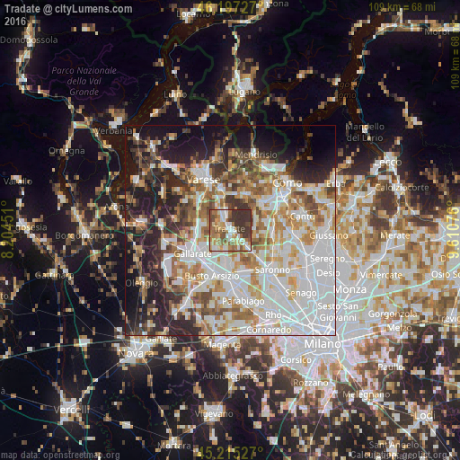
Analysis of Tradate night lights 2016
Square area 10x10 km:
 8.18%
8.18%90-99
14.09%80-89
8.79%70-79
10.3%60-69
14.39%50-59
13.79%40-49
6.36%30-39
23.18%20-29
0.91%10-19
0%0-9
0%Square area 50x50 km:
18.7%90-99
14.26%80-89
5.61%70-79
6.59%60-69
7.78%50-59
6.42%40-49
6.12%30-39
5.95%20-29
9.09%10-19
12.73%0-9
6.76%Clear (daylight) street map image can be seen on geolist.org.
Map coordinates:
46° 11' 50.2" North, 8° 12' 16.2" East
45° 42' 30.3" North, 8° 54' 27.5" East
45° 12' 55" North, 9° 36' 38.7" East
Some cities around Tradate sort by population:
• Fagnano Olona-Bergoro
5.7 km =3.5 mi,  220°
220°
• Mozzate
5.3 km =3.3 mi,  134°
134°
• Castiglione Olona
5.6 km =3.5 mi,  331°
331°
• Appiano Gentile
6.4 km =4 mi,  62°
62°
• Venegono Superiore
5 km =3.1 mi,  350°
350°
• Venegono Inferiore
3.2 km =2 mi,  342°
342°
• Carnago
5.9 km =3.7 mi,  284°
284°
• Gorla Maggiore
5 km =3.1 mi,  190°
190°
3165340 (p: 17,154)
Sources (retrieved 2019-11-25):
» Earth at Night: Flat Maps 2012, 2016