Fagnano Olona-Bergoro night lights from space
Night Light of Fagnano Olona-Bergoro (Lombardy) from space (Italy) Src. Average luminocity for 10x10km area is 84.6833% and for 50x50km: 60.5754%.
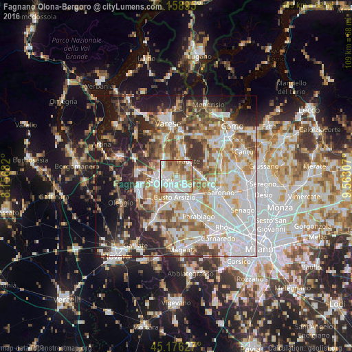
Analysis of Fagnano Olona-Bergoro night lights 2016
Square area 10x10 km:
 26.67%
90-99
28.94%80-89
7.73%70-79
10.91%60-69
14.7%50-59
9.24%40-49
1.82%30-39
0%20-29
0%10-19
0%0-9
0%Square area 50x50 km:
17.36%90-99
14.92%80-89
5.76%70-79
6.92%60-69
8.11%50-59
6.85%40-49
6.61%30-39
6.75%20-29
10.4%10-19
12.28%0-9
4.04%Clear (daylight) street map image can be seen on geolist.org.
Map coordinates:
46° 9' 32.2" North, 8° 9' 24.6" East
45° 40' 11.2" North, 8° 51' 35.8" East
45° 10' 34.6" North, 9° 33' 47.1" East
Some cities around Fagnano Olona-Bergoro sort by population:
• Gallarate
5.4 km =3.4 mi,  258°
258°
• Cassano Magnago
2.6 km =1.6 mi,  275°
275°
• Tradate
5.7 km =3.5 mi,  40°
40°
• Olgiate Olona
4 km =2.5 mi,  155°
155°
• Gorla Minore
4.6 km =2.9 mi,  133°
133°
• Cavaria Con Premezzo
5.1 km =3.2 mi,  299°
299°
• Solbiate Olona
2.8 km =1.7 mi,  141°
141°
• Gorla Maggiore
2.8 km =1.7 mi,  103°
103°
3177279 (p: 11,906)
Sources (retrieved 2019-11-25):
» Earth at Night: Flat Maps 2012, 2016