Venegono Superiore night lights from space
Night Light of Venegono Superiore (Lombardy) from space (Italy) Src. Average luminocity for 10x10km area is 60.9746% and for 50x50km: 53.1858%.
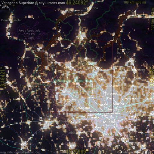
Analysis of Venegono Superiore night lights 2016
Square area 10x10 km:
 8.41%
8.41%90-99
11.11%80-89
7.14%70-79
9.05%60-69
11.11%50-59
15.4%40-49
9.05%30-39
27.78%20-29
0.95%10-19
0%0-9
0%Square area 50x50 km:
14.63%90-99
12.65%80-89
5.06%70-79
6.31%60-69
7.07%50-59
6.3%40-49
6.17%30-39
5.98%20-29
7.74%10-19
15.29%0-9
12.8%Clear (daylight) street map image can be seen on geolist.org.
Map coordinates:
46° 14' 27.3" North, 8° 11' 39.2" East
45° 45' 8.9" North, 8° 53' 50.4" East
45° 15' 34.9" North, 9° 36' 1.7" East
Some cities around Venegono Superiore sort by population:
• Tradate
5 km =3.1 mi,  170°
170°
• Malnate
4.8 km =3 mi,  344°
344°
• Olgiate Comasco
6.5 km =4 mi,  57°
57°
• Castiglione Olona
1.9 km =1.2 mi,  270°
270°
• Appiano Gentile
6.8 km =4.2 mi,  106°
106°
• Vedano Olona
2.7 km =1.7 mi, 343°
• Carnago
6 km =3.7 mi,  235°
235°
• Albizzate
7.8 km =4.8 mi,  248°
248°
3164608 (p: 6,393)
Sources (retrieved 2019-11-25):
» Earth at Night: Flat Maps 2012, 2016