Venegono Inferiore night lights from space
Night Light of Venegono Inferiore (Lombardy) from space (Italy) Src. Average luminocity for 10x10km area is 60.0636% and for 50x50km: 54.9566%.
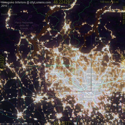
Analysis of Venegono Inferiore night lights 2016
Square area 10x10 km:
 7.27%
7.27%90-99
10.45%80-89
6.36%70-79
7.42%60-69
14.7%50-59
15.45%40-49
9.85%30-39
27.58%20-29
0.91%10-19
0%0-9
0%Square area 50x50 km:
15.83%90-99
12.95%80-89
5.18%70-79
6.39%60-69
7.28%50-59
6.37%40-49
6.13%30-39
6.01%20-29
7.96%10-19
15.15%0-9
10.76%Clear (daylight) street map image can be seen on geolist.org.
Map coordinates:
46° 13' 27.4" North, 8° 11' 32.4" East
45° 44' 8.5" North, 8° 53' 43.6" East
45° 14' 34" North, 9° 35' 54.9" East
Some cities around Venegono Inferiore sort by population:
• Tradate
3.2 km =2 mi,  162°
162°
• Malnate
6.6 km =4.1 mi,  350°
350°
• Olgiate Comasco
7.8 km =4.8 mi,  46°
46°
• Castiglione Olona
2.6 km =1.6 mi,  316°
316°
• Appiano Gentile
6.6 km =4.1 mi,  90°
90°
• Vedano Olona
4.5 km =2.8 mi, 352°
• Carnago
5 km =3.1 mi,  252°
252°
• Albizzate
7.2 km =4.5 mi,  262°
262°
3164609 (p: 6,065)
Sources (retrieved 2019-11-25):
» Earth at Night: Flat Maps 2012, 2016