Gorla Maggiore night lights from space
Night Light of Gorla Maggiore (Lombardy) from space (Italy) Src. Average luminocity for 10x10km area is 80.6848% and for 50x50km: 63.9689%.
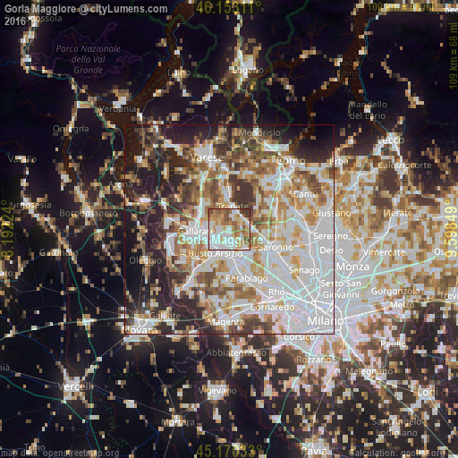
Analysis of Gorla Maggiore night lights 2016
Square area 10x10 km:
 21.97%
90-99
24.09%80-89
9.85%70-79
11.97%60-69
14.85%50-59
11.06%40-49
2.88%30-39
3.33%20-29
0%10-19
0%0-9
0%Square area 50x50 km:
20.41%90-99
15.51%80-89
5.98%70-79
7.12%60-69
8.14%50-59
6.73%40-49
6.45%30-39
6.57%20-29
10.32%10-19
10.23%0-9
2.54%Clear (daylight) street map image can be seen on geolist.org.
Map coordinates:
46° 9' 11.2" North, 8° 11' 32.1" East
45° 39' 50" North, 8° 53' 43.3" East
45° 10' 13.2" North, 9° 35' 54.6" East
Some cities around Gorla Maggiore sort by population:
• Cassano Magnago
5.4 km =3.4 mi,  279°
279°
• Tradate
5 km =3.1 mi,  10°
10°
• Castellanza
5.9 km =3.7 mi,  179°
179°
• Olgiate Olona
3.2 km =2 mi,  199°
199°
• Fagnano Olona-Bergoro
2.8 km =1.7 mi, 283°
• Mozzate
4.9 km =3 mi,  75°
75°
• Marnate
4.1 km =2.5 mi,  164°
164°
• Solbiate Olona
1.8 km =1.1 mi,  214°
214°
3175984 (p: 5,043)
Sources (retrieved 2019-11-25):
» Earth at Night: Flat Maps 2012, 2016