Appiano Gentile night lights from space
Night Light of Appiano Gentile (Lombardy) from space (Italy) Src. Average luminocity for 10x10km area is 65.8545% and for 50x50km: 60.2887%.
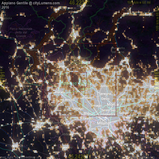
Analysis of Appiano Gentile night lights 2016
Square area 10x10 km:
 12.42%
90-99
16.82%80-89
6.21%70-79
11.36%60-69
11.52%50-59
6.97%40-49
7.12%30-39
26.67%20-29
0.91%10-19
0%0-9
0%Square area 50x50 km:
19.81%90-99
14.56%80-89
5.78%70-79
7.34%60-69
7.82%50-59
5.97%40-49
5.46%30-39
5.36%20-29
7.18%10-19
9.55%0-9
11.17%Clear (daylight) street map image can be seen on geolist.org.
Map coordinates:
46° 13' 25" North, 8° 16' 40.5" East
45° 44' 6" North, 8° 58' 51.7" East
45° 14' 31.5" North, 9° 41' 3" East
Some cities around Appiano Gentile sort by population:
• Tradate
6.4 km =4 mi,  242°
242°
• Olgiate Comasco
5.6 km =3.5 mi,  349°
349°
• Lurate Caccivio
3.8 km =2.4 mi,  21°
21°
• Fino Mornasco
5.4 km =3.4 mi,  80°
80°
• Lomazzo
5.9 km =3.7 mi,  135°
135°
• Villa Guardia
5.5 km =3.4 mi,  36°
36°
• Cadorago-Caslino al Piano
4.5 km =2.8 mi,  101°
101°
• Guanzate
3.1 km =1.9 mi,  105°
105°
3182965 (p: 6,926)
Sources (retrieved 2019-11-25):
» Earth at Night: Flat Maps 2012, 2016