Sant'Angelo Lodigiano night lights from space
Night Light of Sant'Angelo Lodigiano (Lombardy) from space (Italy) Src. Average luminocity for 10x10km area is 38.0394% and for 50x50km: 40.204%.
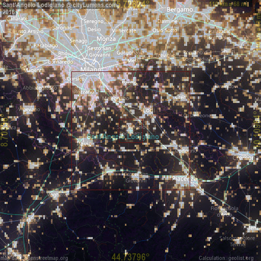
Analysis of Sant'Angelo Lodigiano night lights 2016
Square area 10x10 km:
 4.7%
4.7%90-99
6.97%80-89
3.79%70-79
4.09%60-69
4.7%50-59
2.27%40-49
1.82%30-39
9.24%20-29
28.33%10-19
34.09%0-9
0%Square area 50x50 km:
7.61%90-99
8.09%80-89
3.88%70-79
3.52%60-69
4.56%50-59
4.38%40-49
4.77%30-39
6.5%20-29
18.3%10-19
29.83%0-9
8.55%Clear (daylight) street map image can be seen on geolist.org.
Map coordinates:
45° 43' 41.7" North, 8° 42' 12.2" East
45° 14' 6.9" North, 9° 24' 23.4" East
44° 44' 16.7" North, 10° 6' 34.7" East
Some cities around Sant'Angelo Lodigiano sort by population:
• Lodi
11.1 km =6.9 mi,  41°
41°
• Melegnano
15.1 km =9.4 mi,  334°
334°
• Lodi Vecchio
7.7 km =4.8 mi,  6°
6°
• San Colombano al Lambro
8.7 km =5.4 mi,  131°
131°
• Spino d'Adda
19.5 km =12.1 mi,  18°
18°
• Belgioioso
11.2 km =7 mi,  220°
220°
• Siziano
18.2 km =11.3 mi,  299°
299°
• Tavazzano
10.3 km =6.4 mi,  359°
359°
3167439 (p: 11,516)
Sources (retrieved 2019-11-25):
» Earth at Night: Flat Maps 2012, 2016