Sezze night lights from space
Night Light of Sezze (Latium) from space (Italy) Src. Average luminocity for 10x10km area is 23.1207% and for 50x50km: 21.8233%.
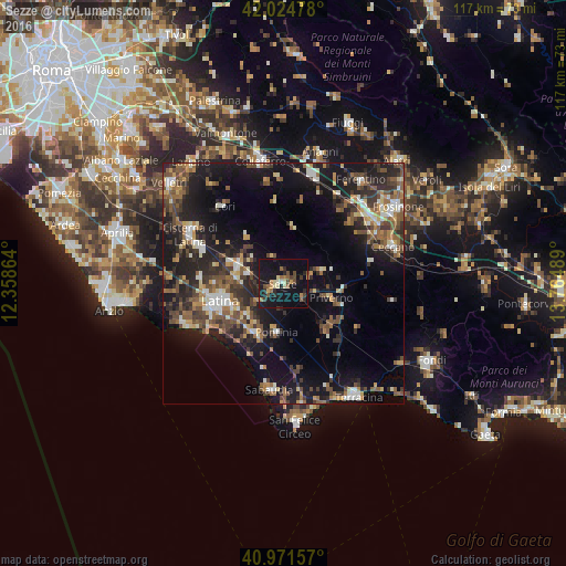
Analysis of Sezze night lights 2016
Square area 10x10 km:
 0.34%
0.34%90-99
1.19%80-89
4.25%70-79
1.7%60-69
4.76%50-59
3.23%40-49
4.59%30-39
2.89%20-29
6.46%10-19
40.31%0-9
30.27%Square area 50x50 km:
1.65%90-99
3.08%80-89
2.33%70-79
2.05%60-69
3.01%50-59
4.65%40-49
4.4%30-39
4.3%20-29
7.5%10-19
18.33%0-9
48.71%Clear (daylight) street map image can be seen on geolist.org.
Map coordinates:
42° 1' 29.2" North, 12° 21' 31.1" East
41° 30' 1.2" North, 13° 3' 42.3" East
40° 58' 17.7" North, 13° 45' 53.6" East
Some cities around Sezze sort by population:
• Latina
13.7 km =8.5 mi,  253°
253°
• Cisterna di Latina
21.9 km =13.6 mi,  297°
297°
• Priverno
10.3 km =6.4 mi,  108°
108°
• Sabaudia
22.4 km =13.9 mi,  187°
187°
• Latina Scalo
10.3 km =6.4 mi,  289°
289°
• Segni
21.3 km =13.2 mi,  350°
350°
• Pontinia
10.1 km =6.3 mi, 189°
• Cori
20.3 km =12.6 mi,  321°
321°
3166571 (p: 16,071)
Sources (retrieved 2019-11-25):
» Earth at Night: Flat Maps 2012, 2016