Latina Scalo night lights from space
Night Light of Latina Scalo (Latium) from space (Italy) Src. Average luminocity for 10x10km area is 41.9354% and for 50x50km: 24.1718%.
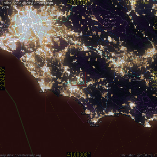
Analysis of Latina Scalo night lights 2016
Square area 10x10 km:
 3.4%
3.4%90-99
6.29%80-89
4.76%70-79
4.08%60-69
5.27%50-59
6.8%40-49
11.39%30-39
14.12%20-29
19.9%10-19
22.62%0-9
1.36%Square area 50x50 km:
1.85%90-99
3.23%80-89
2.61%70-79
2.35%60-69
3.58%50-59
4.61%40-49
5.22%30-39
5.16%20-29
9.01%10-19
20.51%0-9
41.86%Clear (daylight) street map image can be seen on geolist.org.
Map coordinates:
42° 3' 20.8" North, 12° 14' 33.2" East
41° 31' 53.7" North, 12° 56' 44.4" East
41° 0' 11.1" North, 13° 38' 55.7" East
Some cities around Latina Scalo sort by population:
• Velletri
22.1 km =13.7 mi,  320°
320°
• Cisterna di Latina
11.8 km =7.3 mi,  303°
303°
• Colleferro
22.3 km =13.9 mi,  12°
12°
• Sezze
10.3 km =6.4 mi,  109°
109°
• Priverno
20.6 km =12.8 mi, 109°
• Segni
18.5 km =11.5 mi,  19°
19°
• Pontinia
15.7 km =9.8 mi,  148°
148°
• Cori
12.8 km =8 mi,  347°
347°
8426434 (p: 6,883)
Sources (retrieved 2019-11-25):
» Earth at Night: Flat Maps 2012, 2016