Priverno night lights from space
Night Light of Priverno (Latium) from space (Italy) Src. Average luminocity for 10x10km area is 15.8878% and for 50x50km: 19.4855%.
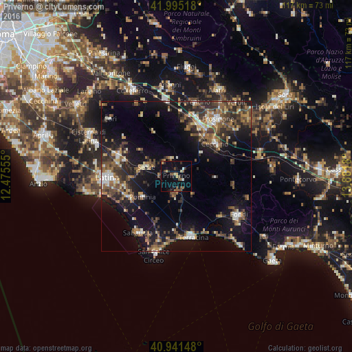
Analysis of Priverno night lights 2016
Square area 10x10 km:
 0%
0%90-99
1.36%80-89
1.7%70-79
2.38%60-69
0.34%50-59
4.76%40-49
3.74%30-39
1.36%20-29
3.57%10-19
10.54%0-9
70.24%Square area 50x50 km:
1.4%90-99
2.64%80-89
1.9%70-79
1.99%60-69
2.56%50-59
4.31%40-49
4.19%30-39
4.04%20-29
5.63%10-19
14.86%0-9
56.48%Clear (daylight) street map image can be seen on geolist.org.
Map coordinates:
41° 59' 42.6" North, 12° 28' 32" East
41° 28' 13.7" North, 13° 10' 43.2" East
40° 56' 29.3" North, 13° 52' 54.5" East
Some cities around Priverno sort by population:
• Latina
22.9 km =14.2 mi,  268°
268°
• Frosinone
23.2 km =14.4 mi,  35°
35°
• Terracina
20.6 km =12.8 mi,  164°
164°
• Sezze
10.3 km =6.4 mi,  288°
288°
• Ceccano
16.9 km =10.5 mi,  47°
47°
• Sabaudia
22.7 km =14.1 mi,  213°
213°
• Latina Scalo
20.6 km =12.8 mi, 289°
• Pontinia
13.1 km =8.1 mi,  239°
239°
3169811 (p: 10,005)
Sources (retrieved 2019-11-25):
» Earth at Night: Flat Maps 2012, 2016