Pontinia night lights from space
Night Light of Pontinia (Latium) from space (Italy) Src. Average luminocity for 10x10km area is 19.4796% and for 50x50km: 16.9619%.
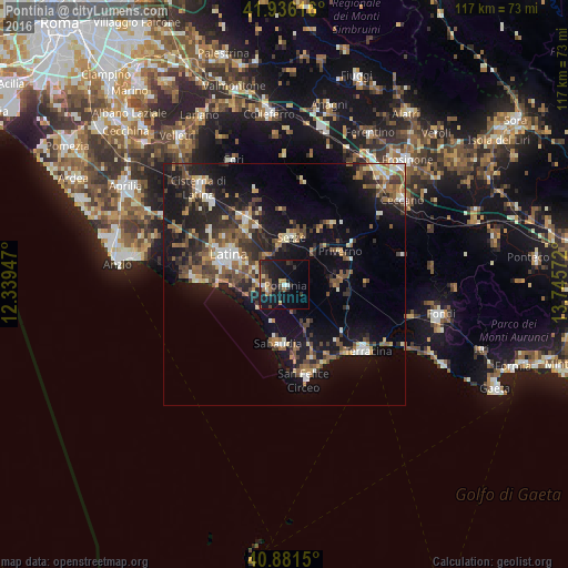
Analysis of Pontinia night lights 2016
Square area 10x10 km:
 1.19%
1.19%90-99
1.7%80-89
1.36%70-79
1.87%60-69
2.72%50-59
3.23%40-49
3.06%30-39
5.61%20-29
6.46%10-19
27.89%0-9
44.9%Square area 50x50 km:
1.29%90-99
2.37%80-89
1.8%70-79
1.6%60-69
2.35%50-59
3.17%40-49
3.4%30-39
3.23%20-29
5.66%10-19
14.85%0-9
60.29%Clear (daylight) street map image can be seen on geolist.org.
Map coordinates:
41° 56' 10.2" North, 12° 20' 22.1" East
41° 24' 39.5" North, 13° 2' 33.3" East
40° 52' 53.4" North, 13° 44' 44.6" East
Some cities around Pontinia sort by population:
• Latina
13.1 km =8.1 mi,  298°
298°
• Terracina
21.4 km =13.3 mi,  128°
128°
• Cisterna di Latina
26.8 km =16.7 mi,  318°
318°
• Sezze
10.1 km =6.3 mi,  9°
9°
• Priverno
13.1 km =8.1 mi,  59°
59°
• Sabaudia
12.4 km =7.7 mi,  185°
185°
• Latina Scalo
15.7 km =9.8 mi,  328°
328°
• San Felice Circeo
19.8 km =12.3 mi,  167°
167°
3170196 (p: 6,407)
Sources (retrieved 2019-11-25):
» Earth at Night: Flat Maps 2012, 2016