Borgo San Lorenzo night lights from space
Night Light of Borgo San Lorenzo (Tuscany) from space (Italy) Src. Average luminocity for 10x10km area is 14.2206% and for 50x50km: 13.6032%.
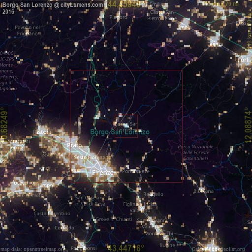
Analysis of Borgo San Lorenzo night lights 2016
Square area 10x10 km:
 3.17%
3.17%90-99
3.17%80-89
0%70-79
1.27%60-69
0%50-59
2.06%40-49
3.33%30-39
0.63%20-29
1.75%10-19
4.6%0-9
80%Square area 50x50 km:
3.84%90-99
3.3%80-89
0.85%70-79
0.95%60-69
1.33%50-59
1.74%40-49
1.42%30-39
1.61%20-29
2.87%10-19
3.4%0-9
78.69%Clear (daylight) street map image can be seen on geolist.org.
Map coordinates:
44° 27' 34.2" North, 10° 40' 57" East
43° 57' 19.7" North, 11° 23' 8.2" East
43° 26' 49.8" North, 12° 5' 19.5" East
Some cities around Borgo San Lorenzo sort by population:
• Florence
22.6 km =14 mi,  209°
209°
• Sesto Fiorentino
20.3 km =12.6 mi,  227°
227°
• Calenzano
20.9 km =13 mi,  237°
237°
• Pontassieve
20.4 km =12.7 mi,  169°
169°
• Vaiano
21 km =13 mi,  273°
273°
• Barberino di Mugello
12.9 km =8 mi,  292°
292°
• Vernio
21.4 km =13.3 mi,  298°
298°
• Scarperia
4.9 km =3 mi,  329°
329°
3181754 (p: 9,716)
Sources (retrieved 2019-11-25):
» Earth at Night: Flat Maps 2012, 2016